
Plaetje:New Brunswick topographic map-fr.svg

Afmetingen van deze voorvertoning van het type PNG van dit SVG-bestand: 610 × 600 pixels Andere resoluties: 244 × 240 pixels | 488 × 480 pixels | 781 × 768 pixels | 1.042 × 1.024 pixels | 2.083 × 2.048 pixels | 2.237 × 2.199 pixels.
Volledige resolutie (SVG-bestand, nominaal 2.237 × 2.199 pixels, bestandshroôtte: 3,31 MB)
Saemenvattieng
| Beschrijving |
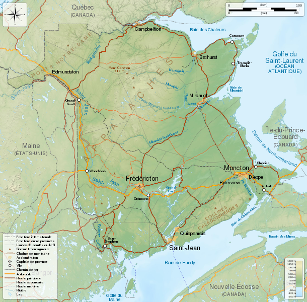
English: General map of New Brunswick, Canada, with topographic bakground (embeded raster file). French version.
Equirectangular projection, WGS84 datum
Geographic limits of the map:
Français : Carte générale du Nouveau-Brunswick, Canada, avec un fond topographique (fichier matriciel incorporé). Version en français.
Projection équirectangulaire, système géodétique WGS84.
Limites géographiques de la carte :
|
||
| Datum | |||
| Bron |
Eigen werk. English:
Français : |
||
| Auteur | Sémhur (talk) | ||
| Andere versies | |||
| Naamsvermelding (required by the license) | © Sémhur / Wikimedia Commons / | ||
| SVG | W3C-validity not checked. Deze niet W3C-verklaarde vectorafbeelding is gemaakt met Inkscape .
|
||
| Graphic Lab |

| Cameralocatie | | Deze en andere afbeeldingen in: OpenStreetMap |
|---|
Licentie
Ik, de auteursrechthebbende van dit werk, maak het hierbij onder de volgende licenties beschikbaar:
| Copyleft: dit kunstwerk is vrij; u mag het heruitgeven en/of wijzigen in overeenkomst met de voorwaarden van de Free Art-licentie.
U kunt een voorbeeld van de licentie vinden op de website van Copyleft Attitude als ook op andere websites. |
This file is licensed under the Creative Commons Attribution-Share Alike Attribution-Share Alike 4.0 International, 3.0 Unported, 2.5 Generic, 2.0 Generic and 1.0 Generic license.
- De gebruiker mag:
- Delen – het werk kopiëren, verspreiden en doorgeven
- Remixen – afgeleide werken maken
- Onder de volgende voorwaarden:
- naamsvermelding – U moet op een gepaste manier aan naamsvermelding doen, een link naar de licentie geven, en aangeven of er wijzigingen in het werk zijn aangebracht. U mag dit op elke redelijke manier doen, maar niet zodanig dat de indruk wordt gewekt dat de licentiegever instemt met uw werk of uw gebruik van zijn werk.
- Gelijk delen – Als u het werk heeft geremixt, veranderd, of erop heeft voortgebouwd, moet u het gewijzigde materiaal verspreiden onder dezelfde licentie als het oorspronkelijke werk, of een daarmee compatibele licentie.
U mag zelf één van de licenties kiezen.
Bestandsgeschiedenisse
Klik op 'n datum/tied om 't bestand te zien zoas 't van d'r tied woas.
| Datum/tied | Miniatuur | Ofmetiengen | Gebruker | Opmerkienge | |
|---|---|---|---|---|---|
| hudige versie | 23 mei 2014 07:06 | | 2.237 × 2.199 (3,31 MB) | Sémhur | Valid SVG |
| 29 nov 2011 21:18 |  | 2.237 × 2.199 (3,31 MB) | Sémhur | == {{int:filedesc}} == {{Information |Description={{Multilingual description |en=General map of New Brunswick, Canada, with topographic bakground (embeded raster file). French version. Equirectangular projection, WGS84 datum *Standa |
Bestandsgebruuk
Dit bestand òdt op de volgende pagina gebruukt:
Globaal bestandsgebruik
De volgende andere wiki's gebruiken dit bestand:
- Gebruikt op bn.wikipedia.org
- Gebruikt op en.wikipedia.org
- Gebruikt op fr.wikipedia.org
- Gebruikt op hu.wikipedia.org
- Gebruikt op id.wikipedia.org
- Gebruikt op incubator.wikimedia.org
- Gebruikt op kk.wikipedia.org